
Extract Video Frame As Photo Standalone Geotagged JPEGs with EXIF Lat/Lng and Stamp
Turn GoPro survey video into portable, location-aware photographs. Instantly load extracted frames into ArcGIS, QGIS, Lightroom, or client reports with embedded GPS coordinates, precise timestamps, and metadata—processed 100% locally in your browser.
The application was intuitive to use and displayed exactly the kind of information we needed to show to our clients. It was very convenient not having to download additional software on the user or client side. Whenever video roadway survey work comes along, we know who to turn to!
— Donovan Bradshaw, Lead Geotechnical Engineer

Loved it. Having worked with it the past few months with a few guys, it’s been very easy to work with. With the amount of video files we have, all we need to have is an external hard drive plugged in and that’s it. Earlier this week, we sat down with the town to show them the work we’ve done, and they loved it as well
. — Victor Zhang, PE Sr. Structural/Bridge Engineer
The maps.video local application has made it really easy to access and control HD video playback, which has made determining the location of roadway features very efficient. It’s allowed me to create a fully mapped video library of a city or town’s road network using hardware (GoPro cameras) that I already owned.
— Lance Baden, Consultant

The application was intuitive to use and displayed exactly the kind of information we needed to show to our clients. It was very convenient not having to download additional software on the user or client side. Whenever video roadway survey work comes along, we know who to turn to!
— Donovan Bradshaw, Lead Geotechnical Engineer
Loved it. Having worked with it the past few months with a few guys, it’s been very easy to work with. With the amount of video files we have, all we need to have is an external hard drive plugged in and that’s it. Earlier this week, we sat down with the town to show them the work we’ve done, and they loved it as well
. — Victor Zhang, PE Sr. Structural/Bridge Engineer
The maps.video local application has made it really easy to access and control HD video playback, which has made determining the location of roadway features very efficient. It’s allowed me to create a fully mapped video library of a city or town’s road network using hardware (GoPro cameras) that I already owned.
— Lance Baden, Consultant
Recording continuous survey video with a GoPro action camera captures high-density visual and spatial data across road networks, utility corridors, and civil construction sites. However, raw video files are difficult to share with clients, integrate into GIS databases, or attach to formal engineering reports. Traditional workflows force teams to choose between cumbersome unmapped video files or tedious manual photo logging.
Maps.video bridges this gap with advanced local telemetry extraction. By parsing the camera's high-frequency GPS metadata directly inside your local web browser—without uploading a single megabyte to external cloud servers—maps.video allows you to record a route once, then extract precise, high-resolution video frames at any exact location, stationing point, or distance interval.
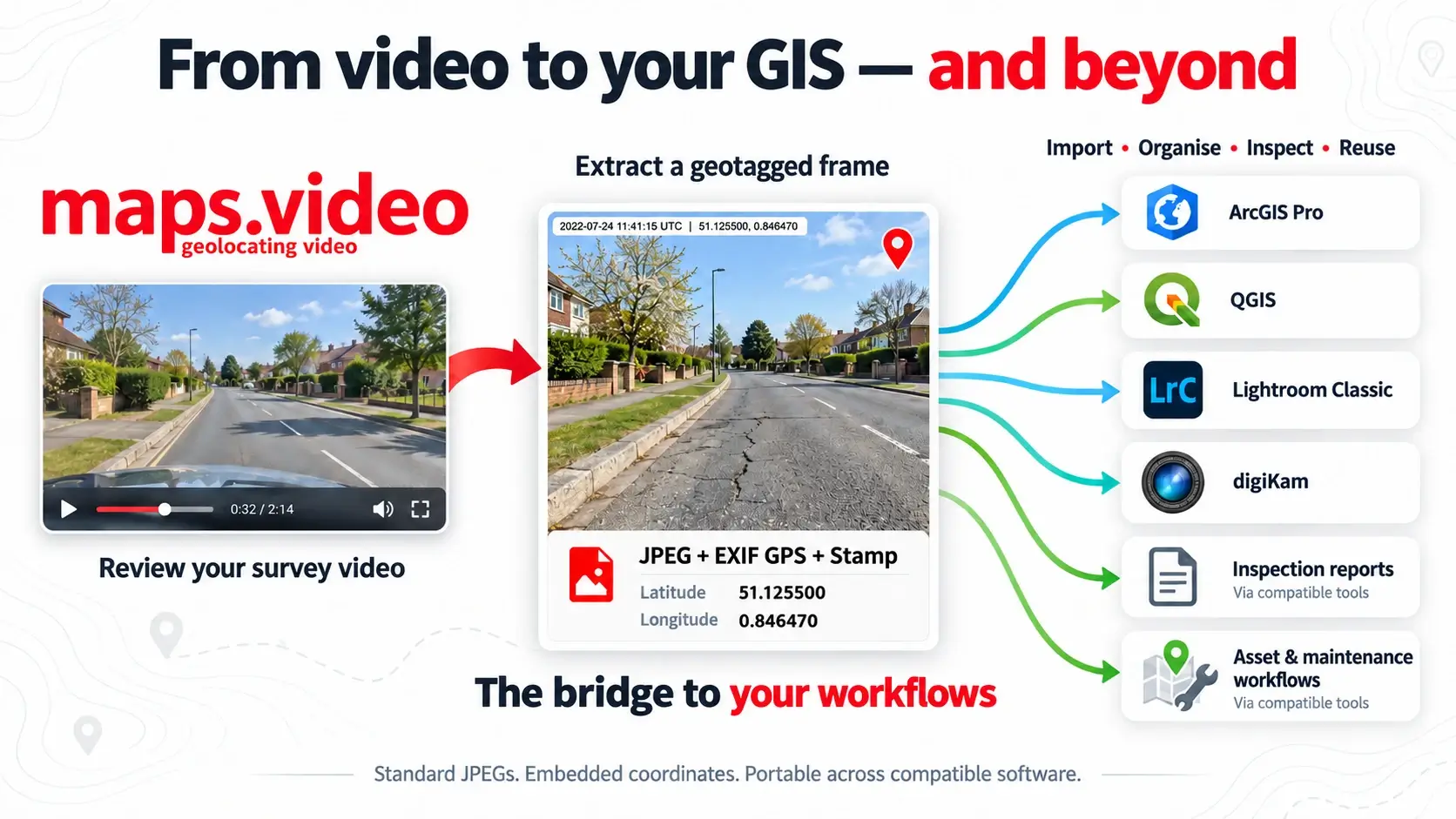
Every extracted frame is generated as a standalone, location-aware JPEG photograph with embedded EXIF latitude, longitude, and DateTimeOriginal metadata. This transforms transient video playback into portable spatial data that integrates seamlessly across desktop GIS, asset management, digital archiving, and reporting tools.

Line the local video up with the mouse wheel and extract the video frame.

Open the medium resolution photo. Get in touch if you want your logo burned into photos.
Workflows & Uses Enabled by EXIF-Tagged Frame Extraction
Because EXIF coordinates and capture timestamps make each extracted frame an independent, location-aware photo, this feature unlocks powerful operational use cases across engineering, GIS, and management:
Before, During & After Proof of Work
For paving and utility contractors, capture chronological visual evidence across every project phase. Extract time-stamped and location-aware frames to prove pre-existing site conditions, document active trenching or paving layers, and verify final surface restoration for rapid client sign-offs and pay app approvals.
Defending Pre-Existing Damage Claims
Protect your business from unearned liability and costly disputes. Use geolocated and time-stamped extracted frames to conclusively prove that pre-existing pavement cracking, kerb damage, or surrounding property defects existed before your crew mobilized on site.
GIS Integration (ArcGIS & QGIS)
Instantly ingest folders of extracted JPEGs into desktop GIS platforms. Use ArcGIS Pro's GeoTagged Photos To Points or QGIS's Import geotagged photos tool to convert image directories into interactive spatial point layers with clickable photo popups.
Searchable Photo Archives (Lightroom & digiKam)
Build private, map-based survey photo libraries without heavy GIS software. Import geotagged JPEGs into Lightroom Classic or digiKam to browse, sort, and search thousands of site photos geographically by location and capture date.
Maintenance & Work Orders
Extract frames capturing potholes, faded striping, damaged road signs, or blocked stormwater drains. Use the embedded coordinate metadata to feed inspection findings directly into maintenance management and ticketing systems.
Automated Inspection Reports
Bundle extracted JPEGs into professional PDF inspection schedules, civil reports, or compliance packages. Each image retains its precise coordinates, capture timestamp, and stationing reference beside the visual evidence.
Automatic Project Sorting
Sort massive batches of site photographs into distinct project boundaries, road sections, or contract areas by automatically comparing their EXIF coordinate metadata against spatial shapefiles or KML project zones.
AI-Assisted Inspection Pipelines
Feed geotagged survey frames into computer vision or machine learning scripts. While EXIF supplies the precise geographic location, AI pipelines can analyze visual content for pavement cracking, asset counts, or anomaly detection.
Frictionless Client Handovers
Deliver a folder of standalone, geotagged JPEGs alongside a survey report. Clients and municipal asset owners can import the imagery directly into their own mapping systems without needing a maps.video account or cloud login.
Before-and-After Time-Series Records
Retrieve and compare photographs taken near the exact same geographic coordinates across successive survey visits. Build multi-year visual timelines to track road wear, vegetation growth, or construction progress.
Compelling Before and After GPS Video Proof
Find features quickly and extract sharable, geolocated, time stamped jpegs

Standard EXIF & Companion Deliverables Included
Engineered for maximum portability and downstream compatibility across professional software ecosystems
True EXIF Latitude & Longitude
Every extracted frame writes precise GPS coordinates directly into the standard EXIF header of the JPEG file. Note: These coordinates reflect the physical location of the camera at the moment of recording, rather than the exact position of a specific feature or asset visible ahead in the frame.
DateTimeOriginal EXIF Metadata
Every extracted JPEG features the `DateTimeOriginal` EXIF tag automatically set to the exact date and time of the source video frame when it was recorded in the field—ensuring accurate chronological and temporal tracking across all asset records.
Source Video & Playback Traceability
Maintain complete auditing accountability. Filename ids link each JPEG back to its source video filename and exact playback timestamp, allowing inspectors to re-examine surrounding footage instantly.
KML Route & Marker Layer Downloads
Download the complete video GPS path and all point-of-interest (POI) markers as a KML file directly from the map interface, allowing you to load survey tracks and photo pins as choosable GIS layers.
Simple Field Hardware: Use the Cameras You Already Own
Equip your paving vehicles or survey poles with GPS-enabled GoPro action cameras—no expensive proprietary hardware or multi-sensor rigs required.

How to Extract Geotagged Frames in 3 Simple Steps
Fast, local, browser-based workflow with zero cloud upload delays
Works with GoPro HERO13, HERO11, HERO10, HERO9, HERO8, HERO7, HERO6, HERO5, Mission 1 Series, MAX2, MAX, Fusion, Session 5 and .gpx.
Drop Video & Parse Telemetry
Open maps.video and drop your GoPro MP4 file into the browser. Telemetry is parsed instantly on your local device with zero cloud upload required.
Navigate & Line Up Video
Use your mouse wheel or click any point along the interactive route map to jump the video player directly to the exact frame of interest.
Export EXIF-Tagged Photo
Click the extract button to download a high-resolution JPEG complete with embedded EXIF latitude, longitude, DateTimeOriginal timestamp, and optional burned-in branding.
Frame Extraction & Deliverables Comparison
How maps.video EXIF frame exports compare to manual screenshots and unmapped video files
| Feature / Capability | Standard Video Screenshots | Handheld Smartphone Photos | Maps.video EXIF Extraction |
|---|---|---|---|
| Spatial Metadata (EXIF) | None (No coordinates attached) | Variable (Depends on phone GPS lock) | Precise GoPro GPS Telemetry Embedded (Camera Position) |
| Temporal Metadata (DateTimeOriginal) | None / System export time | Phone system time | Exact Video Recording Date & Time |
| Route Continuity | None (Disconnected video file) | Spotty (Gaps between snapshots) | 100% Continuous Linear Survey Coverage |
| GIS & Software Compatibility | Requires manual coordinate lookup | Requires manual folder sorting | Instant Drop-In for ArcGIS, QGIS & Lightroom |
| Data Privacy & Security | Cloud hosting required on most tools | Local storage | 100% Local Browser Processing (Zero Uploads) |
Frequently Asked Questions
Everything you need to know about EXIF lat/lng frame extraction and downstream software compatibility
Q: What software can read the EXIF GPS coordinates and timestamps in extracted frames?
A: Any software that supports standard JPEG EXIF metadata. This includes desktop GIS platforms like ArcGIS Pro and QGIS, photo management apps like Lightroom Classic and digiKam, and most reporting and spreadsheet tools.
Q: Do the extracted JPEGs require an active internet connection or maps.video login to view?
A: No. Once extracted, each JPEG is a completely standalone, portable file containing its own GPS coordinates and DateTimeOriginal metadata in the EXIF header. You can hand them off to clients or municipalities who do not use maps.video.
Q: What camera hardware is supported for telemetry extraction?
A: Maps.video is engineered specifically for GoPro action cameras with built-in GPS telemetry (such as GoPro HERO models), which embed high-accuracy spatial coordinates and timestamps directly into recorded MP4 video files.
Q: Does maps.video upload my survey video to cloud servers during extraction?
A: No, your survey video files are never uploaded and remain completely private on your machine. However, the extracted GPS telemetry and route data are stored in the cloud to render and power your interactive project maps.
"The maps.video local application has made it really easy to access and control HD video playback... It's allowed me to create a fully mapped video library of a city or town's road network using hardware (GoPro cameras) that I already owned."
Turn Your Survey Video Into GIS-Ready Photo Records
Record your road or utility corridor once with a GoPro, parse telemetry locally, and extract location-aware JPEGs for ArcGIS, QGIS, client handovers and work proof.
Test maps.video with Sample Footage