
Download KML Routes Export Video Tracks & Photo POIs
Instantly export your mapped video routes and yellow point-of-interest photo markers into Google Earth or Esri ArcGIS for professional GIS analysis, asset inspection, and reporting.
The application was intuitive to use and displayed exactly the kind of information we needed to show to our clients. It was very convenient not having to download additional software on the user or client side. Whenever video roadway survey work comes along, we know who to turn to!
— Donovan Bradshaw, Lead Geotechnical Engineer

Loved it. Having worked with it the past few months with a few guys, it’s been very easy to work with. With the amount of video files we have, all we need to have is an external hard drive plugged in and that’s it. Earlier this week, we sat down with the town to show them the work we’ve done, and they loved it as well
. — Victor Zhang, PE Sr. Structural/Bridge Engineer
The maps.video local application has made it really easy to access and control HD video playback, which has made determining the location of roadway features very efficient. It’s allowed me to create a fully mapped video library of a city or town’s road network using hardware (GoPro cameras) that I already owned.
— Lance Baden, Consultant

The application was intuitive to use and displayed exactly the kind of information we needed to show to our clients. It was very convenient not having to download additional software on the user or client side. Whenever video roadway survey work comes along, we know who to turn to!
— Donovan Bradshaw, Lead Geotechnical Engineer
Loved it. Having worked with it the past few months with a few guys, it’s been very easy to work with. With the amount of video files we have, all we need to have is an external hard drive plugged in and that’s it. Earlier this week, we sat down with the town to show them the work we’ve done, and they loved it as well
. — Victor Zhang, PE Sr. Structural/Bridge Engineer
The maps.video local application has made it really easy to access and control HD video playback, which has made determining the location of roadway features very efficient. It’s allowed me to create a fully mapped video library of a city or town’s road network using hardware (GoPro cameras) that I already owned.
— Lance Baden, Consultant
Screenshots and Instructions
Follow these simple steps to download and open your KML files in desktop GIS software
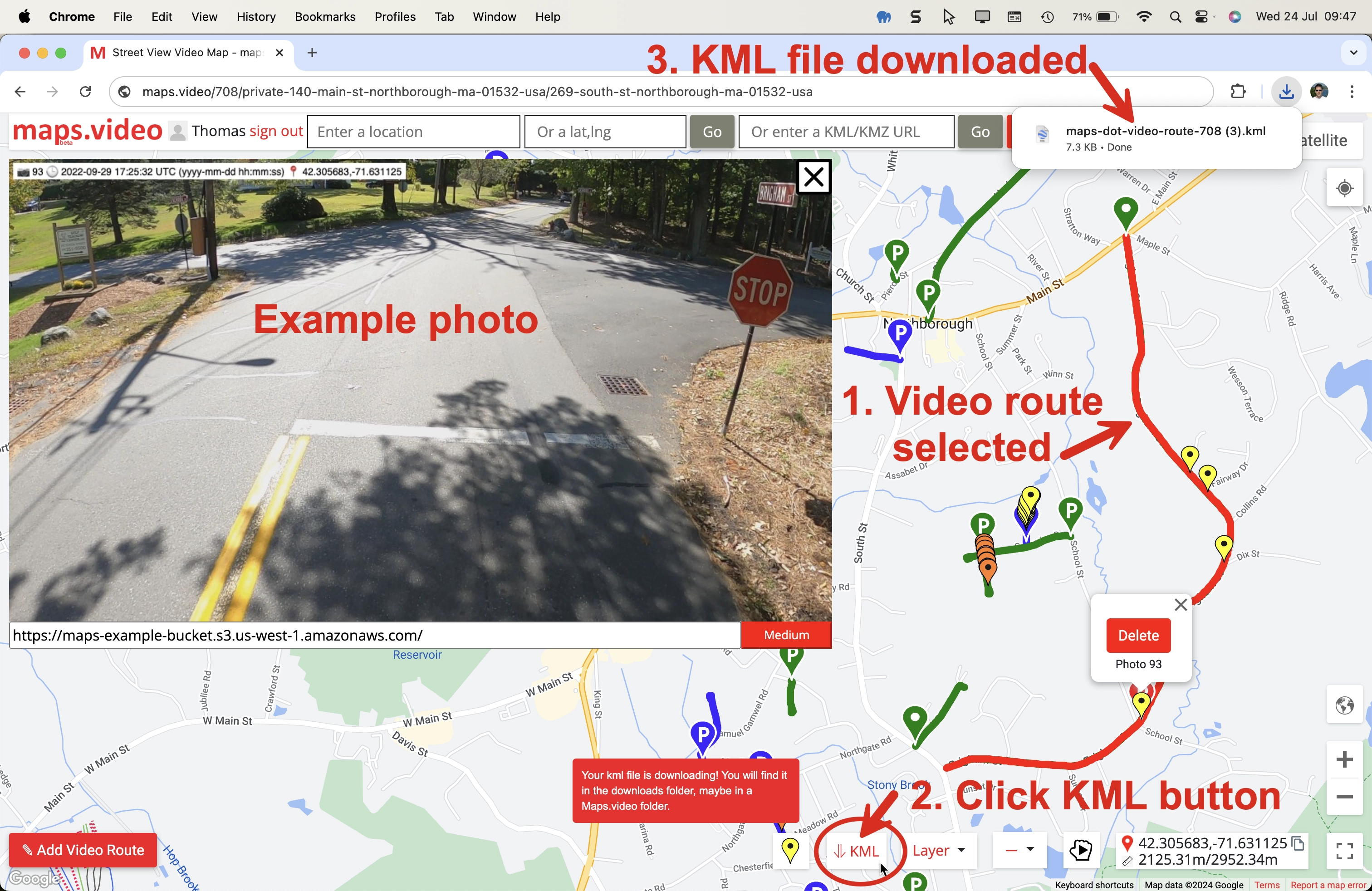
Click the download KML button in the map (ringed) and the video route and yellow POI markers will download as a KML file to the downloads folder.
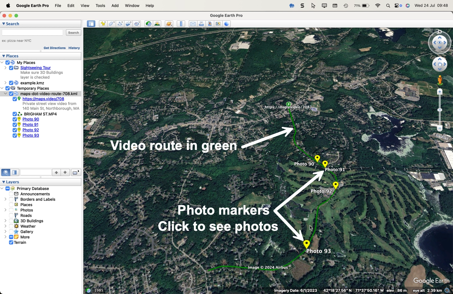
Double click the KML file in the downloads folder to open in Google Earth or esri ArcGIS.
Here we can see the video route in light green and the yellow POI markers.
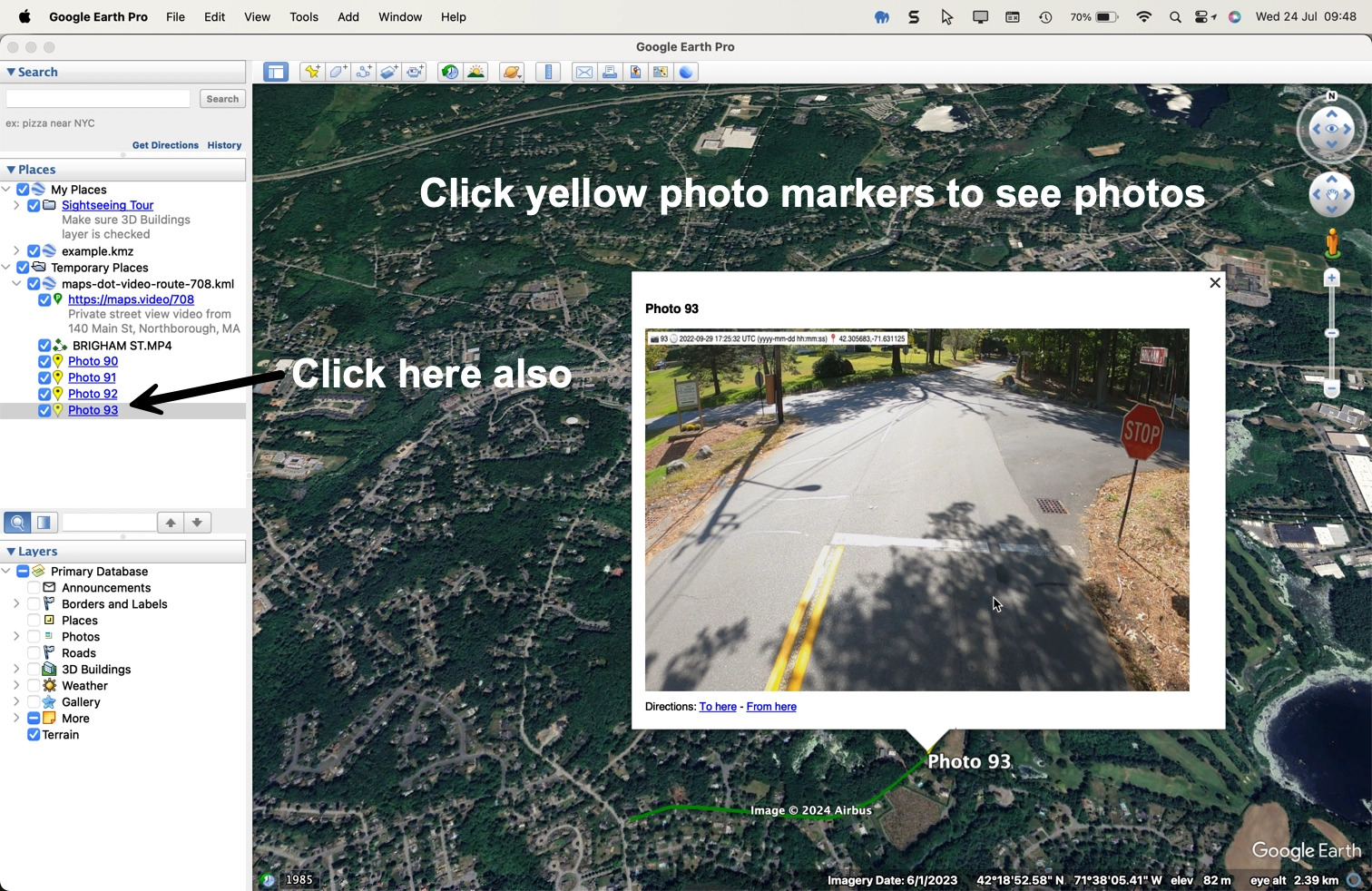
Click a yellow photo marker to see the photo.
You can open, browse the KML listings in the left side bar and open individual POI photos.
How Downloadable KML Layers Help Paving, Utilities, and Infrastructure
Integrate field video captures and spatial photo markers directly into professional GIS workflows
For Paving & Highway Contractors
Export KML route layers to verify paving extents, document pre- and post-construction surface conditions, and share precise linear project milestones with municipal inspectors and project owners.
- Import video tracks straight into ArcGIS or Google Earth Pro.
- Pinpoint exact locations of surface defects or patching areas using photo POIs.
- Enhance client reporting with verifiable spatial evidence.
For Utility & Trenching Teams
Turn linear video inspections of trench runs and duct banks into structured KML overlays. Archive visual evidence of underground asset alignments before backfilling occurs.
- Cross-reference video coordinates with engineering GIS databases.
- Access site photos instantly via interactive map markers in Google Earth.
- Streamline compliance auditing and as-built documentation.
For Infrastructure & Public Works
Distribute lightweight KML files across project teams to review field assets, bridge conditions, and right-of-way corridors without requiring specialized video playback software.
- Seamless compatibility with standard GIS desktop applications.
- Organize field assets neatly in the left-hand sidebar directory.
- Bridge the gap between raw video footage and enterprise GIS mapping.
"The maps.video local application has made it really easy to access and control HD video playback... It's allowed me to create a fully mapped video library of a city or town's road network using hardware (GoPro cameras) that I already owned."
Export Your Field Routes to KML Today
Streamline your GIS workflow by converting GoPro video telemetry into standard KML formats for Google Earth and Esri ArcGIS. Test the platform with sample footage or jump straight into the interactive map.